
On a Sunday in late May, I pointed the truck toward Porcupine Mountains Wilderness State Park to head out on my long run training for an upcoming ultra. This was my first time in the Porkies and I wasn’t sure what to expect. The past few weeks had brought bugs so unbearable you couldn’t have any exposed skin. Dousing myself in DEET, I left the Government Peak Trailhead behind and headed up the rocky trail through the woods.
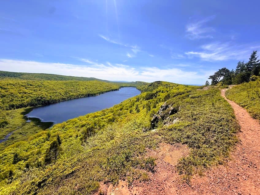
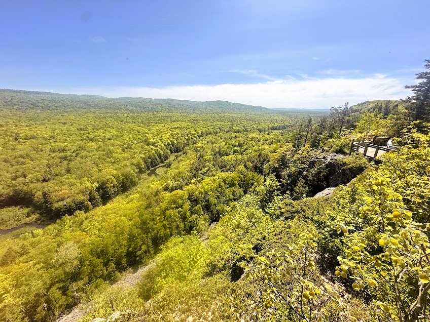
Emerging from the trees up onto the ancient rocky ridge splitting Lake Superior from Lake of the Clouds, the day was sunny, windy and most of all mosquito-free! I felt so blessed. The views and the almost alpine-esque habitat along the Escarpment Trail quickly skyrocketed it to the top of my personal list of best Midwest hiking trails.
Escarpment Trail Quick Stats!
Distance: 4.2 miles one-way, 8.4 miles roundtrip (out-and-back)
Vertical Gain: 1,076 feet
Difficulty: Moderate
Unique Rocky Outcrop Habitat: 10/10
Time required: 3-5 hours
Permit required: Recreation Passport
Dog-friendly? Yes, but should be kept on a leash.
Family-friendly? There are some steeper cliff drop-offs but older kids will like the views and varied terrain to explore.
Escarpment Trail Trailheads
I wouldn’t consider the Escarpment Trail a “hidden gem”, as it is well-known as a must-do for visitors to the Porcupine Mountains. However, getting to the Porkies in the first place is a pretty long haul for most people, so the trail brings much more solitude than it would if it were located closer to large population centers.
There are multiple trailheads for the Escarpment Trail:
Government Peak Trailhead
Click here for Google Maps directions
Starting from the Government Peak Trailhead on the east end of the trail, you gain elevation right off the bat as the rocky trail climbs through hardwood forests. Once the trail reaches the top of the escarpment, the views just get more impressive as you work your way west.
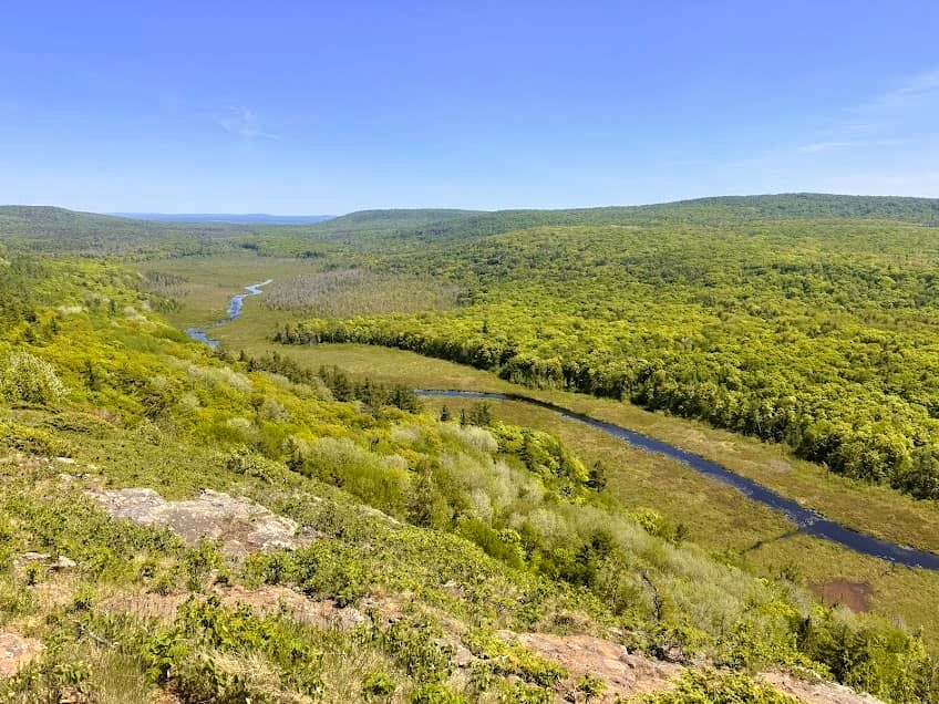
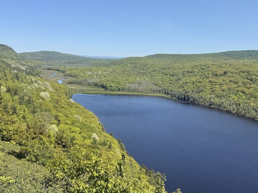
Views of the Carp River valley and the river winding through the trees below give way to the first glimpses of Lake of the Clouds, and even occasionally Lake Superior on the other side of the peaks to the north.
Lake of the Clouds Overlook
Click here for Google Maps directions
If you prefer to hike west to east, start at the Lake of the Clouds Overlook parking area. This trailhead is much more popular and developed, as many people choose to simply view the Lake of the Clouds rather than hike the trail. The overlook has interpretive signs, viewing platforms and a nice wooden boardwalk.
Cloud Peak Trailhead
Click here for Google Maps directions
The Cloud Peak trailhead is located at the middle of the Escarpment Trail off of a short spur. This is a good option if you only want to hike half of the trail; to the east is the Carp River valley and to the west is Lake of the Clouds.
Hiking the Escarpment Trail – Porcupine Mountains
There are more than 90 miles of trails in the UP’s Porcupine Mountains Wilderness State Park, making it the best state park for backpacking in Michigan. While you do have to reserve backcountry campsites ahead of time, you can put together a really varied multi-day hike.
Click here for a guide on how to plan and execute a multi-day backpacking route!
Upper Carp River Valley
From Government Peak Trailhead, once the trail emerges up on top of the escarpment, you’ll see the Upper Carp River, which winds through a valley as it makes its way to Lake Superior. Keep an eye out for wildlife down below, especially in the evenings and early mornings.
Plants Along the Escarpment Trail
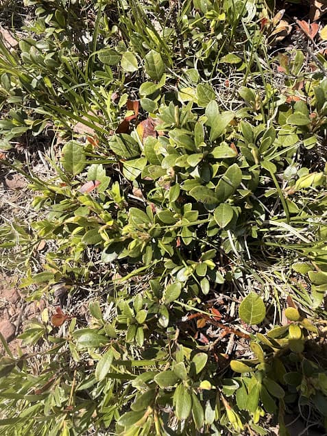
The landscape of the escarpment is highly unique for the Midwest. The exposed rock and the plant communities that live there have an alpine appearance. Young red oaks, shrubs and forbs line the trail and grow between the cracks in the rock.
Kinnikinnick, a fruit-bearing plant in the heather family, is one such species that does well in poor soils. Kinnikinnick spreads through rhizomes, and its bright red berries attract wildlife that spread the plant’s seeds. Other species found on top of the escarpment include redroot, serviceberry, rusty woodsia, low juniper, and Prairie Cat’s-foot, which is a critical early food source for pollinators. Prairie Cat’s-foot, also known as field pussytoes, have a soft flower that resembles a cat’s paw. This plant reproduces asexually and does well in disturbed or poor soils.
Porkies Wildlife
The Porcupine Mountains are home to much of the UP’s endemic wildlife species. I have seen snowshoe hare, white-tailed deer, black bear, porcupine, otter, beaver, and wild turkeys, as well as wolf scat while hiking in the Porkies. In the spring, migrating warblers such as American redstart, red-eyed vireo, and Blackburnian warbler can be heard in the area around the Escarpment trail.
Early spring is a great time to view wildlife from the Escarpment trail before the leaves really start to obscure views. Spend some time sitting up above the Carp River Valley and keep an eye out for the diversity of wildlife that utilize the river’s riparian area below. The Carp River and Lake of the Clouds are known for good bass fishing.
Lake of the Clouds
Formerly called Carp Lake, the mile-long lake fed by the Carp River is known today as the much more lyrical “Lake of the Clouds.” Good, we don’t want our lakes named after invasive species, anyway!
Lake of the Clouds is a Michigan highlight, and one of the most photographed spots in the Upper Peninsula. Most visitors choose to simply see the lake from the overview spot you can drive to, but the advantage of hiking the Escarpment trail is the variety of gorgeous lake views you get as you move along the trail. There are even some points along the trail where Lake Superior and Lake of the Clouds can be viewed simultaneously.
Hiking Options and Extending the Hike
If you complete the entire Escarpment Trail, it will be an 8.4 mile out-and-back hike. With a shuttle, 4.2 miles. This particular trail is an excellent out-and-back because the views are so different facing east vs. west. I would highly recommend taking in the scenery from both directions! Be sure to have a Michigan Recreation Passport to access the Porcupine Mountains Wilderness State Park.
To continue on further past the Lake of the Clouds overlook, the trail continues as the Big Carp River Trail. This will take you down through old growth forest, past waterfalls and to the mouth of the Big Carp River at Lake Superior.
Safety Considerations for the Escarpment Trail
While this is a very popular trail within the Porkies, there are some areas with pretty steep drop-offs. Use caution around the cliffs. Also, there is no water available along the trail so make sure to bring plenty!

Pingback: Backpacking Grand Island, Michigan: 3-Day Itinerary - the lupine
Pingback: See the Apostle Islands Sea Caves from Above: Hiking Guide - the lupine
Pingback: Hiking the Little Carp River Trail in the Porcupine Mountains - the lupine