
Which South Rim route should I take into the Grand Canyon?
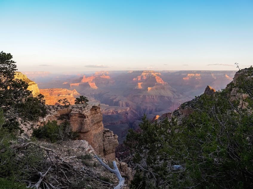
The best part about hiking down into the Grand Canyon is that every switchback in the trail gives a new, more glorious view. If you start at first light (a must), the light changes as the sun moves over the canyon. The stone changes color as the first minutes of the day tick by. The experience is unforgettable just being immersed in the light, shadow and colors of the Big Ditch. Grand Canyon National Park has some of the best hiking in Arizona for a reason.
From the south rim, there are two main trails that hikers can take to the Colorado River at the bottom. The options are the Bright Angel trail or the South Kaibab trail. Both trails have switchbacks and lookout points, so many people hike just a portion of the trail and then turn around. This gives the perk of amazing views without having to hike the massive climb up from the bottom.
The Bright Angel Trail, Grand Canyon
Big ol’ switchbacks, incredible colors, diverse flora
The Bright Angel trail is the more popular route into the canyon because it is located right by Grand Canyon Village, which is the main amenities hub for visitors to the national park. Visitors staying at Grand Canyon Village or just visiting can easily walk to the Bright Angel trailhead.
We stayed at the Mather Campground, our $30 Wal-Mart tent perched between two shiny tricked-out Sprinter vans at the neighboring campsites. Driving around the Mather campground was like visiting an RV/rooftop tent setup/camping van expo, but for free. Staying in a little tent has its benefits, though. Through its thin walls, you can hear the soft early-morning footsteps of the elk wandering among the sleeping campers.
From the Mather Campground, we rose before dawn and got to the very icy Bright Angel trail (this was mid-March) at first light. While the trail is wide and has a rock lip on the edge, some ice cleats would have been helpful. Mule deer watched our slow progress down into the canyon from their breakfast buffets of the green vegetation growing on benches of the canyon walls.
Hiking the Bright Angel trail in the Grand Canyon
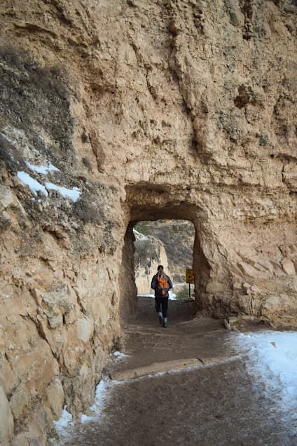
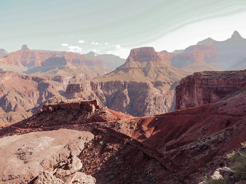
The Bright Angel trail follows an old route down into the canyon that Indigenous people have used for ages. By mile 1.8, you will pass through two different tunnels along the route. The trail switchbacks down the deep side canyon through which it passes on the journey to the Colorado River.
There are resthouses with water at mile 3, mile 6, and the Havasupai Gardens campground. However, be sure to check with the park before setting off to make sure the water is available the day of your hike, as it is seasonal.
While we started our hike in fleece and down, as the sun warmed the cliffs and we descended in elevation, it really warmed up. The lower parts of the canyon are significantly warmer than the higher-elevation South Rim, so layers will keep you comfortable. Check the park website for all current information including heat advisories, trail closures and water availability.
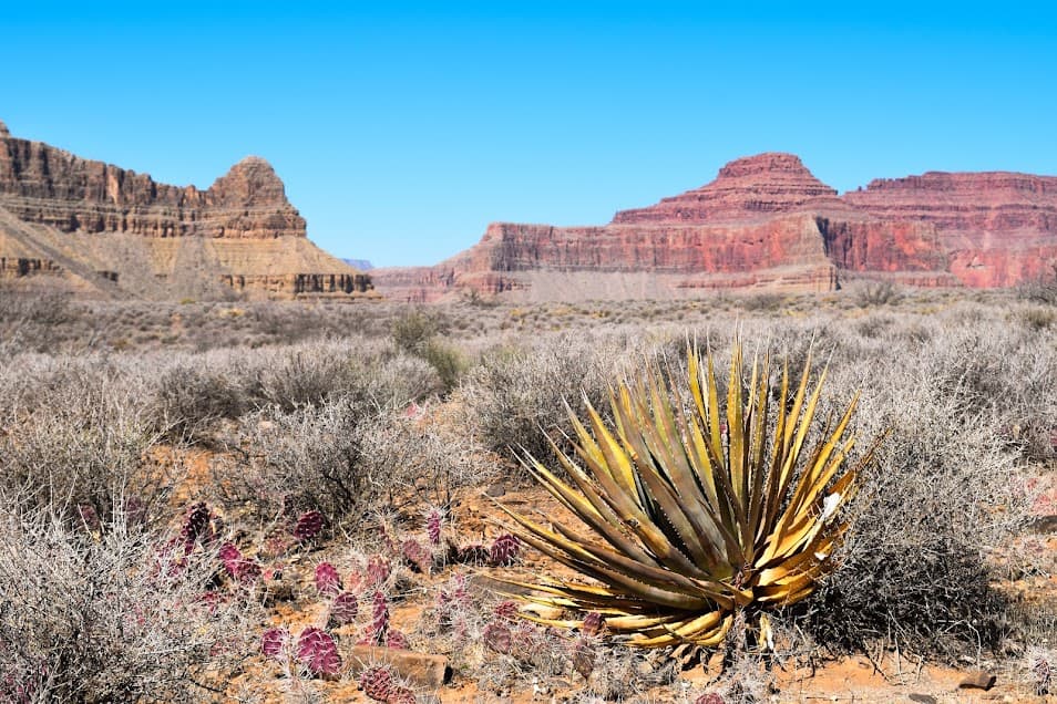
As the trail zigzags down into the canyon, the plant communities change with elevation. Gooseberry, Gambel oak, mountain snowberry and the bright flowering Rubber rabbitbrush lie on the ledges in the upper part of the canyon. The blooms of prickly pear, Penstemon, asters and rockdaisy add to the already marvelous color of the canyon.
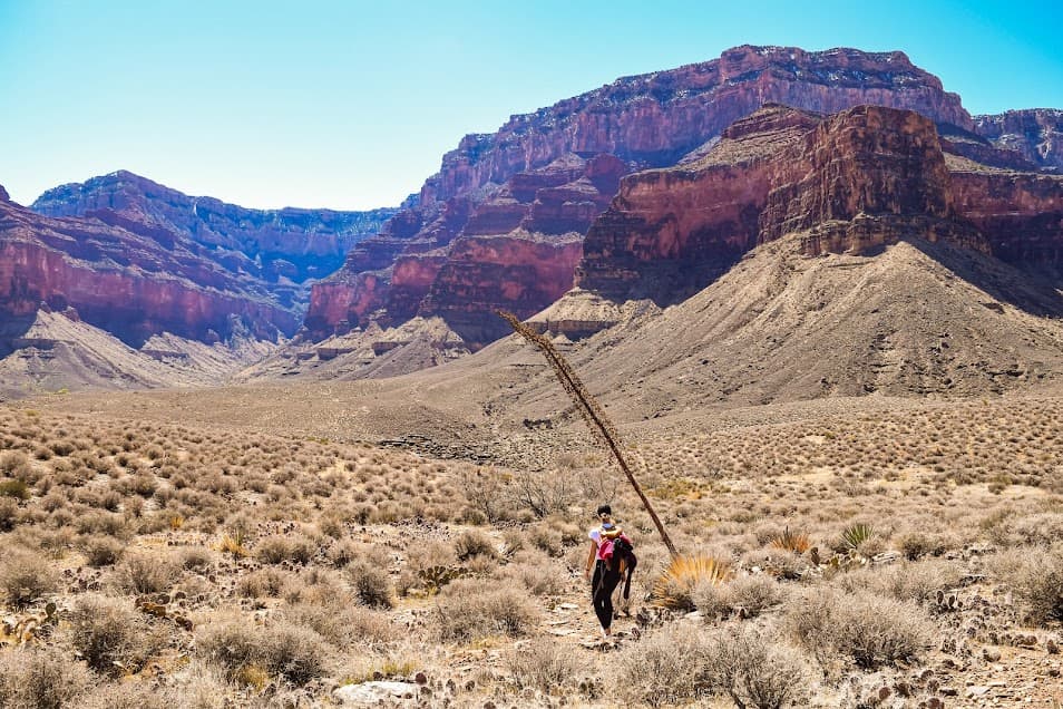
Havasupai Gardens and the Colorado River
After Havasupai Gardens, the Bright Angel trail crosses the West/East Tonto trail, which parallels the river. Taking the East Tonto trail 4 miles will get you to the South Kaibab Trail, from which you can continue on down to the river or back up to the shuttle station at the South Kaibab trailhead. Heading west will take you to the Plateau Point trail, a beautiful sunny plateau that ends with views of the green Colorado River, scores of swallows performing their aerial acrobatics along the cliffs.
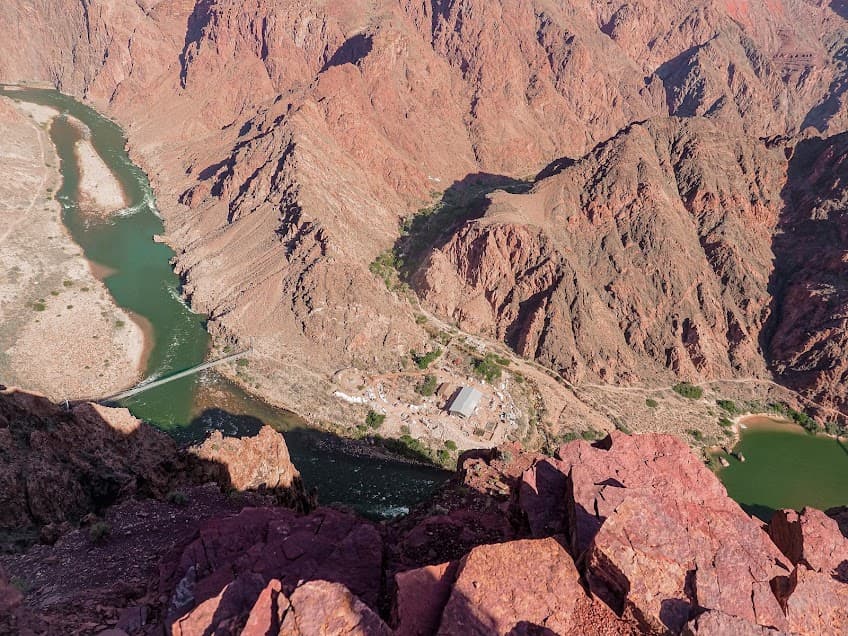
If you choose to follow the Bright Angel trail all the way down to the river, after the trail reaches the Pipe Creek trail shelter, it parallels the river another 1.2 miles heading east toward the Silver Bridge. The bridge crosses the river and leads to Phantom Ranch and the Bright Angel campground. This area is under construction (2025-2026) as the transcanyon waterline is modernized. Check the park website for the most updated closures. Various sections of trail and the Silver Bridge have been closed as work is completed.
From the Bright Angel trailhead to the Silver Bridge is about 9 miles one-way, with 5,000 feet of loss.
The South Kaibab Trail, Grand Canyon
Quicker river access, amazing views, less mileage overall
Just like the Bright Angel trail, we started the South Kaibab trail early. Not only does starting early give you the gift of changing light, shadow and color as the sun moves over the Grand Canyon, but the later you start in the morning, the more people there are on the trail. Descending into the canyon brought early-morning solitude. However, coming back up and out in the afternoon was a constant stream of people making their own journeys into the canyon.
There is no parking at the South Kaibab trailhead, so you have to take a shuttle either from the Grand Canyon visitor center, or one of the hiker express buses from the Bright Angel lodge. If you don’t want to take the shuttle, it’s a 2.5-mile hike along the south rim of the canyon from the visitor center to the trailhead.
Hiking the South Kaibab trail in the Grand Canyon
The April morning we hiked the South Kaibab trail, the wind was absolutely whipping. It was kicking up dust swirls and giving the panoramic views of the canyon an even wilder effect. Something about getting completely thrashed by the wind while standing on the overlooks of the Grand Canyon really makes you feel like an old-timey explorer.
While the Bright Angel trail follows a canyon down, the South Kaibab trail is on an exposed ridge. Pros: Amazing, sweeping views of the Grand Canyon. Slightly fewer people. Less mileage overall. Cons: Exposure to sun, storms and wind. No water source until the Colorado River. The park service recommends extreme caution for those who choose to hike the South Kaibab trail down in the summer. There is no water along the trail and exposure can be severe.
Ooh Aah Point is a whimsically-named vista a mile from the trailhead, with views that correspond to its moniker. So cute!! At mile 3, Skeleton Point is the next named viewpoint (although the whole trail is one big viewpoint) and many hikers choose to turn around here. After Skeleton Point, some switchbacks lower you in elevation and the trail goes another 1.5 miles to where the East Tonto trail crosses. Taking it west will get you over to Havasupai Gardens on the Bright Angel trail. At this point, there is a composting toilet, as well–if you’re drinking sufficient amounts of water, you’ll need it.
Colorado River views and access
From here, we start to get some gorgeous views of the Colorado River. Blooming prickly pear cactus peek from between rocks. Yellow-backed spiny lizards sun themselves nearby, one of 18 species of lizard in Grand Canyon National Park.
Mule trains are common on the South Kaibab trail, so just move to the side as they pass.
At mile 6.25, the trail reaches the Black Bridge across the Colorado River. Birds, plants and dark jade green water contrast with the pink, tan and gold canyon walls. Crossing the Black Bridge takes you to Phantom Ranch/Bright Angel campground, as well as a “Boat Beach” where the Colorado River pack rafts stop. There is a hydrant here at Bright Angel, which is the only reliable water source along the South Kaibab trail.
Both trails in one day: Can I loop it?
Yes, depending on shuttle availability and trail closures due to the transcanyon waterway construction.
To take the South Kaibab trail down to the River Trail, hike west, then hike the Bright Angel Trail back up to the South Rim is a 16-mile hike. Note: The River trail is closed in early 2026… check the park website before heading out. You would want to plan shuttles accordingly depending on whether you park at the Bright Angel Lodge or visitor center.
Pingback: Hiking the Boy Scout Tree Trail in California - the lupine
Pingback: Nambe Lake: Hike an Alpine Lake in New Mexico - the lupine