
Hiking the Doughboys Trail and the North Country Trail at Copper Falls State Park
The 4,800-mile North Country National Scenic Trail runs from Vermont to North Dakota, and by nature it passes through an incredible variety of terrain and habitat types. The NCT runs the length of the Upper Peninsula of Michigan and all the way across Minnesota, but a 200-mile section clips the very northern part of Wisconsin, including a must-see state park.
The Copper Falls section of the North Country Trail
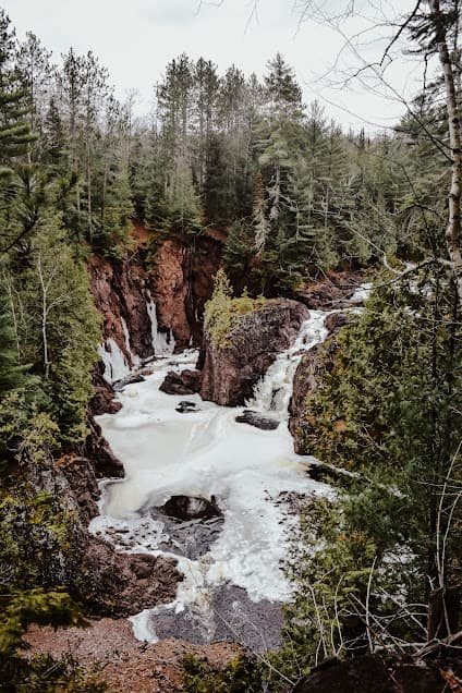
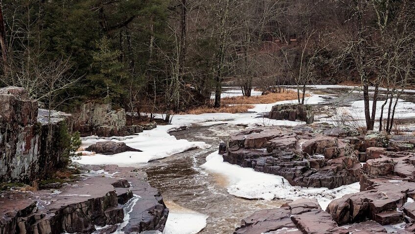
One of the highlights of the Wisconsin section of the North Country Trail is the scenic Copper Falls State Park near Mellen, WI (an official NCT Trail Town). The 3,000-acre Copper Falls State Park encompasses land surrounding the Bad River, which flows south to north through Ashland county to eventually empty into Lake Superior. The Tyler Forks River flows into the Bad River at the epicenter of the park, plunging over Brownstone Falls into the Bad River Gorge.
The Copper Falls State Park section of the North Country Trail runs 9.2 miles through the park, although there are great opportunities to hop off the NCT here and explore some of the other trails in the park, such as the Red Granite Falls trail or some of the loop options around the Bad River Gorge.
Hiking the Doughboys Trail at Copper Falls State Park
The Wisconsin DNR page has an excellent detailed description of the geology of Copper Falls State Park. The combination of red lava, black lava, conglomerate rock, black shale and sandstone give the two scenic waterfalls and the deep gorge itself their beauty that many visitors to the park come to see.
The 1.7-mile Doughboys Trail is the most popular trail in the park because it travels along the most scenic portions of the Bad River Gorge and puts the roaring waterfalls and colorful rocks on full display.
To hike the Doughboys Trail loop, start at the nature center and trailhead, then cross the big log bridge across the Bad River to the left. The river is wide and flat here as it prepares for its plunge down through Copper Falls. The trail takes you up a series of stairs and provides a view of Copper Falls from the river’s left side. Another 300 yards up the trail is the view of Brownstone Falls, where the Tyler Forks River joins the Bad River. Not enough waterfall for your liking? Lucky for you, the trail loops around so you get a look at both waterfalls from the other side!
Another 700 yards past the view of Brownstone Falls, the trail descends a set of stairs and then crosses the Bad River at the Devil’s Gate Bridge. The Doughboy Trail then follows the river right side of the Bad River another mile to another bridge, this one crossing the Tyler Forks River. From here, the trail follows the river down for more overlooks of both Brownstone and Copper Falls before bringing you back to the trailhead.
Wildlife and Trees at Copper Falls
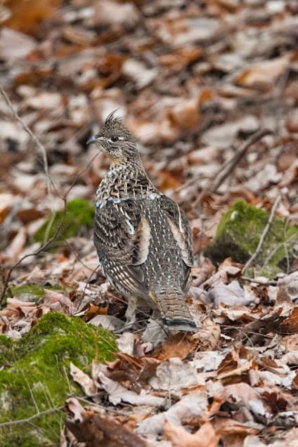
The trail along the Bad River gorge winds through classic northern Wisconsin forests, with tall white pine, hemlock and white cedar trees lining the river here. 500 acres around the scenic waterfalls area of the park have been designated as a Wisconsin State Natural Area. Mammals in the park include all of your usual northern Wisconsin suspects: white-tailed deer, porcupine, black bear, red squirrel, fisher. When I visited in the winter, black-capped chickadees, common ravens and pileated woodpeckers were easily seen along the Doughboy Trail.
Hiking the North Country Trail/Doughboy Loop at Copper Falls State Park
Scenery and Solitude in One Hike
While the Doughboy Trail gets all the hype at Copper Falls State Park, following the North Country Trail north of where it splits off from the Doughboy Trail near Devil’s Gate Bridge brings a quieter hike through some of the lesser-traveled parts of the state park. The NCT north of the falls winds through hardwood forests of ironwood, paper birch, aspen, red oak and basswood, providing views of the Bad River along the route.
For a 9.5-mile hike in the park that gets you all the scenic highlights of the waterfalls while also providing a peaceful walk through the less-visited section of the park, start at the trailhead for the Doughboys Trail and cross the Bad River on the bridge to the left. Follow the Doughboy Trail to where it crosses the Devil’s Gate Bridge, then take the North Country Trail to the left where it splits from the Doughboy Trail.
Detour to Sandy Ledges Trail and Backcountry Campsite
Then, follow the NCT north through the park and make sure to take the short Sandy Ledges side trail for a look at the sandstone ledges by the river in this spot. The Sandy Ledges Trail where it splits off of the NCT is a short detour down to a backcountry campsite along the river. The backcountry campsite is available by reservation only, and is a gorgeous sandstone bluff-laden resting point along the NCT.
Out-and-back North Country Trail Hike along the Bad River
Take the North Country Trail as far as you would like to the north, then turn around (following the NCT all the way to where the Copper Falls State Natural Area border is and turning around there would make it a 9.5-mile roundtrip hike). Really, this hike could be as long or short as you want–the NCT continues to follow the Bad River all the way up to where the state park borders the Bad River Reservation.
After retracing the trail back south toward the waterfalls, take the Little Creek Trail down where it splits from the NCT. The LIttle Creek Trail will bring you back to the bridge across the Tyler Forks River and the Doughboys Trail, which can be followed back to the trailhead and past overlooks for both Copper Falls and Brownstone Falls.
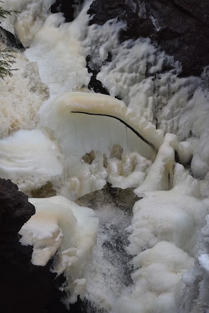
Visiting Copper Falls State Park in the Winter
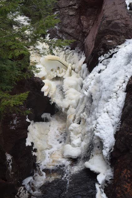
Winter can be an awesome time to visit Copper Falls State Park! Why? No bugs, fewer people and the chance to see the incredible ice formations that line the waterfalls and change by the day.
In the summer, biking, swimming and camping are all popular activities at the park, but in the winter the DNR grooms trails for cross-country skiing (13.7 miles for classic skiing and 6.5 miles for skate skiing). Camping in the winter is also available at six winter campsites that the state park keeps plowed open. The Red Granite Falls trail is a great snowshoe route, and the Doughboy Trail and North Country Trail are also open for hiking and snowshoeing. Check the Wisconsin DNR website for the most up-to-date information about winter trail conditions.
Pingback: See the Apostle Islands Sea Caves from Above: Hiking Guide - the lupine